|
||||||||||||||||||
 |
|
|||||||||||||||||
In the area of the Caribbean Sea, the so-called Cold Fronts are usually formed when any front of hot air coming from the southeast collides with another front of cold air coming from the north, as can be seen to the right of the graph. The line of impact of these two air masses can be presented at different latitudes and longitudes in the Caribbean Sea, as shown in the Dry Climate image located on the Fren Fro towards the northwest. In the image, the meeting place generates a line of climatic instability off the coast of Venezuela with a very characteristic cloudiness
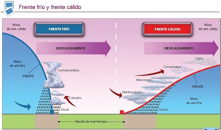
When the mass of cold air moves on the surface of the sea when hitting the mass of hot air displaces it from the surface, this phenomenon is called Cold Front. The mass of cold air is more dense and attacks the hot air below, as if it were a wedge forcing the hot air to rise by doing so ascending almost vertically, as illustrated in the right diagram of the image. This phenomenon is quite violent and in the ascents there are abundant clouds of vertical development. In climatological maps they are represented with a continuous line with triangles like the teeth of a saw. In the case that the masses of hot air move on the cold, because it is the heaviest, it does not separate from the surface of the masr and, even though the mass of cold air is removed, it does not completely dislodge it. Under these conditions the warm air rises gently on the front surface of the cold air mass as if it were on a ramp. In general, the cloudiness is of the stratiform type and the precipitations less intense than those of a Cold Front. In climatological maps it is represented with a red or black continuous line bordered by semicircles.
DICIEMBRE 2017 MAR CARIBE Cold front on the Caribbean Sea that extends from the coasts of Panama diagonally towards the northeast.
The front over the Gulf of Mexico will make a complete transition to a cold front this evening and is forecast to enter NW Caribbean waters on Saturday morning. Strong to near gale-force winds will will follow the front as it moves SE across Cuba Saturday. Gale force winds are forecast to form off the coast of Nicaragua Sunday morning as the tail of the front reaches Costa Rica. There is a high risk of heavy rains for Costa Rica and western Panama Saturday evening through Monday morning associated with this front. Please read the latest NWS High Seas Forecast under AWIPS/WMO headers MIAHSFAT2/FZNT02 for more details.
|
| |||||||||||||||||