Where Hurricanes originate
Being generated by the warm seas and the humid winds of the tropics, all the hurricanes originate in the two narrow strips of the intertropical zone that are to the north and south of the equator. The initial stom gain strength over the course of several days and move westward to the Caribbean, then drift north before running out.
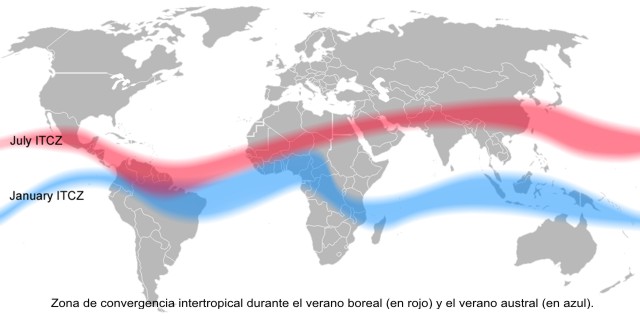
For a long time, scientists have known that the Hurricanes that hit the coasts of the Atlantic Ocean, in North and Central America, are born from storm systems far from the west coast of North Africa. Ironically these storms, the wettest of all, are driven by the climate of one of the driest places on Earth, the Sahara (the name means desert in Arabic).

Between the months of April and May, the Caribbean Sea enters in form of waves coming from the East from the north coast of South America, from that moment the rainy season begins and will continue until November.
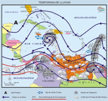
The trade winds from the northeast and southeast give rise to the Intertropical Convergence Zone (ZITC Red line in the figure  ). It is north of this strip, on the waters of the Caribbean Sea, where tropical storms are generated when these winds pass over the warm waters of the Caribbean. ). It is north of this strip, on the waters of the Caribbean Sea, where tropical storms are generated when these winds pass over the warm waters of the Caribbean.
Initially the air currents coming from the center of the Atlantic Ocean appear before entering the Caribbean Sea as a disturbance or ripple in the field of the Trade Winds, forming the Tropical Waves of the east. These undulations with front from north to south move towards the west in a strip between 200 to 300 km at about 20 km / hour causing heavy rainfall in its passage.
The following are the most outstanding climatological phenomena that occur in the Caribbean. If the evolution of these is sequential, the formation of Hurricanes can culminate.
Dependent on wind speed, atmospheric pressure and number of cumulonimbus clouds from the storm, Hurricanes are classified into five categories according to the Saffir-Simpson Hurricane scale. Hurricanes of category 5 are more devastating when they touch land and especially in populated areas with destruction of infrastructure, flooding and death of people and animals. Source: www.fema.gov and www.terra.com.pr

Category 1
Winds of 74 to 95 miles per hour. The tide rises between 4 and 5 feet above normal. There is no significant damage to buildings or buildings, but it can damage motor homes, bushes, trees, and weak traffic signals. Some floods occur on coastal roads.
Category 2
Winds of 96 to 110 miles per hour. The tide rises 6 to 8 feet above normal. Some roofs, doors and windows of buildings and constructions are damaged; shrubs and trees suffer considerable damage, even some trees may fall. Significant damage to motor homes, wharves and weak traffic signals. Some two or four hours before the arrival of the eye of the hurricane, the coastal routes and the evacuation routes that are at low altitude have been flooded. Some small boats at unprotected anchorage sites break the mooring posts.
Category 3
Winds between 111-130 miles per hour. The tide rises between 9 and 12 feet above the normal level. Small structures are destroyed by coastal floods, larger structures are destroyed by the onslaught of waves and floating debris. The trees and shrubs are damaged, they lose their foliage by the force of the wind and some large ones fall. The mobile homes are destroyed. The evacuation routes that are at low altitude have to be cut between 3 and 5 hours before the arrival of the eye of the hurricane because of the high level of water in them. Floods near the coast destroy smaller structures. Land that is less than five feet above sea level and eight miles inland (even more) could be flooded. It may be necessary to evacuate people who live in houses that are at a low level above the sea, even several blocks from the coastline.
Category 4
Winds between 131 and 155 miles per hour. The sea is about 13 or 18 feet from its normal level. More widespread faults in the walls, and some roofs of small residences collapse. Bushes, trees and all the signs on the street are knocked down. Total destruction of mobile homes. Extensive damage to doors and windows. Due to the high water levels, the evacuation routes that are at low altitude must be closed 3 to 5 hours before the arrival of the eye of the hurricane. The ground floor of structures located near the seashore suffer considerable destruction. Grounds that are less than 10 feet above sea level could be flooded forcing the massive evacuation of residential areas that are six miles inland.
Category 5
Winds greater than 155 miles. The tide exceeds 18 feet above the normal level. Many residences and industrial buildings suffer complete failure of their roofs. Some buildings collapse completely. All bushes, trees and traffic signs are knocked down. Complete destruction of mobile homes. Severe and extensive destruction of doors and windows. Evacuation routes that are at low altitude are cut by high water levels between 3 and 5 hours before the arrival of the hurricane center. Serious damage to the ground floors of all structures located less than 15 feet above sea level and 500 yards from the shoreline. Massive evacuation of residential areas located in low elevation areas that are located between 5 and 10 miles from the coastline could be necessary.
Fuente: www.fema.gov y www.terra.com.pr |


